The Reason I have put the word Trips is that there were actually two trips made one week apart. The first trip on May 23rd with me (Rex) and my wife Norma to scout out the trip to make sure we could get though. The second trip was made by the High Priests and Elders one week later on May 30th. The complication is with the Crow Indians and their reservation that we would be traveling on. Sometimes you can travel with no problem, at other times there are no trespassing signs as well as the Indians to turn you around. Norma and I had no trouble with the Indians, just a little mud. So as you look at the following photographs if you see Norma or our Jeep those photos were taken on the first trip with Rex and Norma. If you see a lot of four wheelers and a lot of High Priests and one elder those photos were taken a week later. The mud had dried a lot for the second trip.
This trip is a historical one. When the early Saints were called to colonize Lovell, Cowley and Byron there was a lot of work to be done. The saints needed homes, a canal to bring water to the fields and money to finance everything. When the offer to make a railroad bed for a railroad from Cody to Billings via Pryor Gap. A third of the men worked building homes, a third worked on the Sidon Canal, and a third worked on the railroad bed. The men also blasted a tunnel for the rail road. There was also a town called Bowler that no longer exists. This area is beautiful, green, with wild flowers.
To learn more about the history of the railroad click on the following link.
 |
Members of our four wheeling outing are Rand Tippetts, Brent Leithead, Leroy Collins, Allen Harvey, Don Carter, Scott Davis, Ed Allred, Jay Brinkerhoff, Tom Erwin, and Rex Allen.
|
 |
Our first stop was the Bowler Lime Kiln, Many of the early settlers made use of the lime kiln nearby for the building of their homes. The kiln was “run by one of Jay Brinkerhoff's progenitors at one time.” 4. Lucius R. Maryott, “The Land of Shining Mountains – A Short History of Carbon County,” Carbon County News, February 26, 1970, p. 2. Today, the remains of the kiln are very evident, located along the old railroad grade at the base of the hills east of Bowler, a couple of miles south of the Sage Creek Road – Pryor Creek Road intersection.
|

 |
This is one of the arias where the limestone was mined
 |


 |
After the limestone was baked it is crumbly and can be used as a type of cement
|
 |
These remains are part of the area known as Bowler.
|
 |
Many large farms are all that are left of the town of Bowler.
|
 |
As we continue on we are traveling on the railroad bed that was built by the early saints of Lovell, Cowley, and Byron.
|
 |
The railroad makes a cut through this hill.
|
 |
On our scouting trip Norma and I stopped to look at the many wildflowers along the way.
|
 |
The Indian Paintbrush were numerous and came in many colors.
|
 |
Norma Allen and our Dog Sadie.
|
 |
At this point we are entering Pryor Gap with Castle Rock in the distance.
|
 |
Looking back at Bowler Flats. Still Traveling on the old railroad bed.
|
 |
Sage Creek, the same creak that goes through Cowley
|

 |
This is the cement foundation of the water tower that was used to fill up the trains boilers.
|
 |
The railroad bed as we travel into Pryor gap.
|
 |
This part of the railroad bed was a steep grade.
|
 |
Our scouting trip was a lot muddier than the trip the 4 wheelers made a week later.
|
 |
The use of this platform is unknown, maybe hang gliding?
|


 |
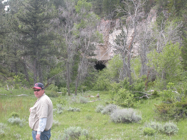
This is the tunnel that was built by the Mormons back in 1901 for the train to pass though.
|

 |
Looking back from the tunnel.
|
 |
| Me |


 |
We all had to go though the tunnel. Here Leroy stands at the other end. Rock falls and overgrowth cover much of the opening.
|
 |
This large ravine was completely filled so the train could pass.
|

 |
Looking North toward the town of Pryor and the heart of the Crow Reservation
|

 |
Below our vantage point at the other end of the Pryor is an Indian home.
|


 |
This is our route as we leave the railroad bed and climb switchbacks to the top of the Pryor Mountains
|
 |
In the above photo we have climbed rapidly from the bottom of Pryor Gap. As we look back the Green Arrow points to the railroad bed, the red arrow points to the south end of the tunnel, and the blue arrow points toward the north end of the tunnel. The photo below shows the same seen without the arrows.
|
 |
About half way up the photo you can see a switch back that we will be traveling on.
|


No comments:
Post a Comment